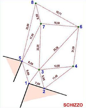
By the method of “trilateration” (seeWikipedia, the free encyclopedia) you can uniquely define the position of a point by measuring its distance from two other known points. And’ based on the construction of a triangle (the three points are the two known + the third to be defined) You must know the three sides.
Is used to detect irregular spaces (without angles) or to define an interior point to a space that is not easy to determine the location).
“Rilievo” allows you to use trilateration. The procedure is simple!
Start by tapping on the point on the display where you think the point to be inserted is approximately. Then tap on the two points from which to take the two construction distances. The keypad will open.
Now you can detect the two distances and enter them in the DIST1 and DIST2 fields. The end point of real-time updates. When you're done awards ![]() (“done”) to confirm the insertion!
(“done”) to confirm the insertion!
Don't worry… It is much easier to do than to explain!